

Where 2.0: A9.com Maps (Beta)

Amazon’s A9 photo mapping service has a bew beta- I really like the new interface and the way the pictures scroll in opposite directions as you mouse over. Pretty solid stuff. Here’s the Seattle area. Link.

Amazon’s A9 photo mapping service has a bew beta- I really like the new interface and the way the pictures scroll in opposite directions as you mouse over. Pretty solid stuff. Here’s the Seattle area. Link.

 David Rumsey did a walk down map memory lane, it was really amazing- Drawing on his personal collection of over 150,000 historical maps as well as his work with geographic information systems, David Rumsey shows how information of all kinds has been mapped and will be mapped in the future. Link. I’m going to get his book Cartographica Extraordinaire.
![]() Amazon’s A9 has a video from when they were capturing images in Washington, DC for their image enhanced search engine. Turns out, the driver of the GPS, wireless enabled truck stopped in front of the State Department- a half dozen security folk showed up, asked questions for about a 30 minutes, the time lapse video the A9 engineer has was funny and scary.Link.
Amazon’s A9 has a video from when they were capturing images in Washington, DC for their image enhanced search engine. Turns out, the driver of the GPS, wireless enabled truck stopped in front of the State Department- a half dozen security folk showed up, asked questions for about a 30 minutes, the time lapse video the A9 engineer has was funny and scary.Link.
![Sunlighttable[1]](http://cdn.makezine.com/make/blogs/blog.makezine.com/SunLightTable%5B1%5D.jpg) The Sunlight Table uses the research carried out in the difficult environment of call centers to provide insight into the wider context of stressful and sedentary office based work. The table brings natural light into workspaces and creates discrete interactions while working, encouraging a dialogue between work and nature, re-establishing a connection with the outside world and creating small opportunities for delight and interaction. Link.
The Sunlight Table uses the research carried out in the difficult environment of call centers to provide insight into the wider context of stressful and sedentary office based work. The table brings natural light into workspaces and creates discrete interactions while working, encouraging a dialogue between work and nature, re-establishing a connection with the outside world and creating small opportunities for delight and interaction. Link.


I’m on my way to the Where 2.0 conference, I’ll be hosting an area at the Where Fair with all my GPS projects I’ve been up to. Coincidentally, Google released Google Earth (free) and I downloaded it and started to tinker. The plus version ($20) allows you do use a GPS so of course I’m already working on a 3D GPS drawing project. Here’s a quick video of how it works (6mb QuickTime MOV). Link.

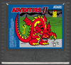 Adventure II is a homebrew homage to Warren Robinett’s original Atari 2600 game, Adventure. Four years in the making, it will soon be available for the Atari 5200 Supersystem as a 32K cartridge filled with many screens to explore, and will be sold with a deluxe glossy manual and professionally die cut box. Expect four kingdoms, sword and keys, changing hedge mazes, brick-layed castle interiors, a thieving Troll, a powerful Minotaur, three hungry dragons and a few surprises on your quest to return the stolen chalice to the Seashore Kingdom’s Castle. Link.