Forrest M. Mims III (forrestmims.org), an amateur scientist and Rolex Award winner, was named by Discover magazine as one of the “50 Best Brains in Science.” His books have sold more than 7 million copies.
Small unmanned aerial vehicles (UAVs or simply drones) have become an important addition to my science tool kit. Not only are they good for aerial imaging, they are ideal for measuring changes in temperature, relative humidity, dew point, and other parameters at various altitudes. The simplest way to use instruments that measure these parameters is to place your instrument’s readout directly in the field of view of the drone’s camera. This allows you to easily see changes in the data simply by viewing the scene on the drone’s controller display. You can also photograph the readout with the camera of the Phantom and other advanced drones to log the altitude, coordinates, and time in the photo’s EXIF file.
Project Steps
SIMPLE INSTRUMENT PLATFORM
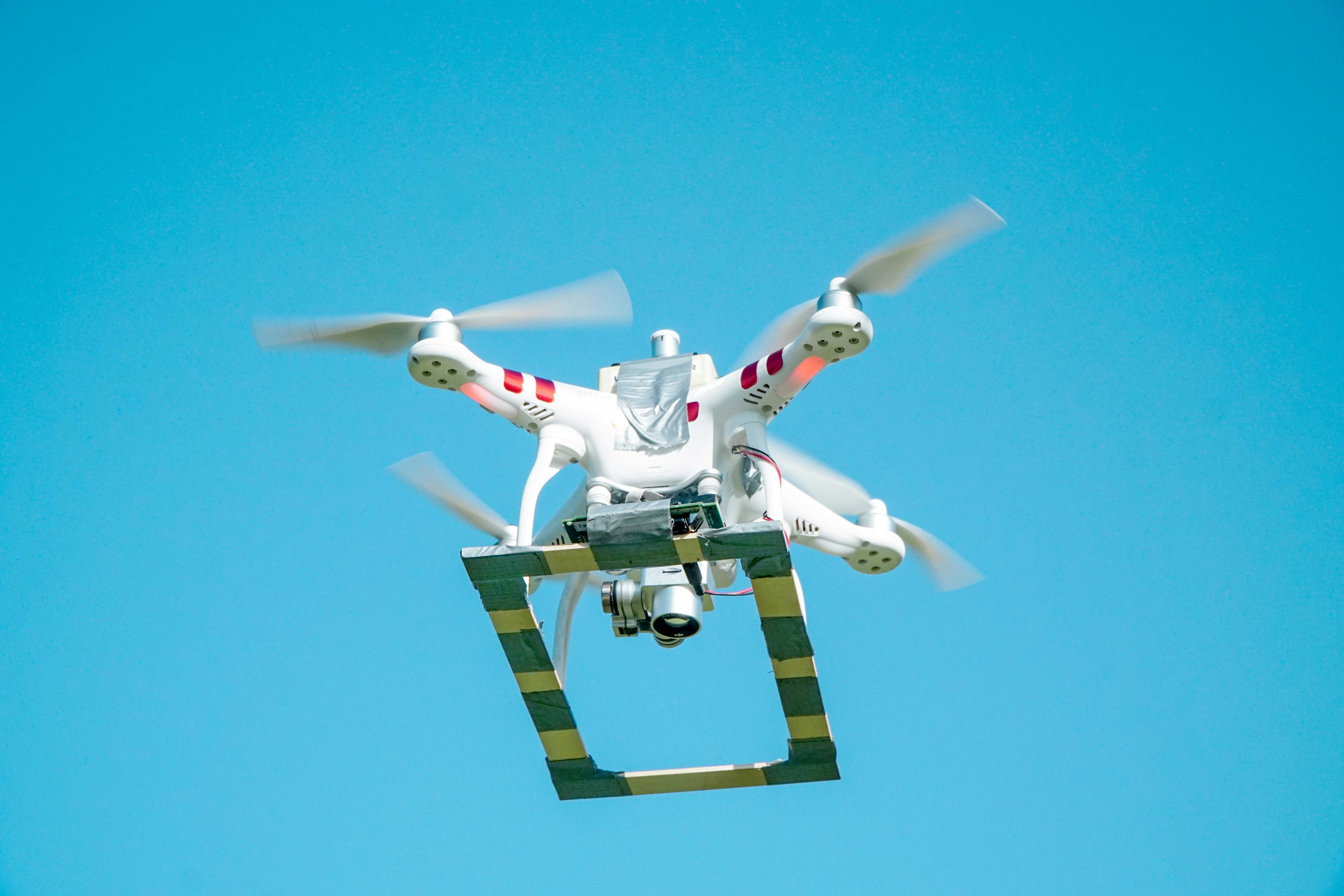
You can easily make a very lightweight platform for flying instruments from a Phantom 3, Phantom 4, or other drones, using two 8″ and two 12″ wood slats (1/8″×1″) from a hobby shop. Attach the slats to one another with duct tape to form a rectangle, then attach the 12″ sides to the bottom of the drone’s landing gear with duct tape. No metal should be used, to avoid possible interference with the drone’s compass. The platform can carry a variety of instruments (Figure A).
TIP: While a drone may be able to fly properly when its center of gravity is changed, a counterweight opposite the payload will reduce the extra load on the motors required to stabilize the drone.
A FLYING ULTRAVIOLET RADIOMETER
The field where I have measured sunlight since 1990 is surrounded by trees. This doesn’t affect measurements of direct sunlight, but the trees have begun to block some of the skylight measured by my full-sky radiometers. The question I’ve long asked is: How much sky blockage have the trees caused? A Phantom 3 drone has provided the answer.
The most important of my full sky measurements is the sun’s ultraviolet-B radiation, and I have long used several DIY radiometers for this purpose. In 1995 and 1997 NASA assigned me to measure the ozone layer and UV-B in Brazil during the annual burning season when vast smoke plumes fill the sky. For these campaigns a UV-B radiometer that I built in 1994 was used, and that’s the radiometer I wanted to fly atop a Phantom 3. This was a risky decision for such a venerable instrument, but I needed to learn the exact difference between the UV-B measured 5 feet and 70 feet over the ground.
Figure B. An Onset 16-bit data logger taped to a drone instrument platform.
The instrument platform described above was used for the test. The attachment magnets were removed from a 16-bit Onset data logger, which was then duct-taped to the platform (Figure B). The radiometer was very carefully taped to the exact center of the top of the Phantom (Figure C). The propeller tips were less than an inch away from the radiometer, so I made sure the radiometer and connection wires were firmly taped in place. Three flights answered the question: the trees were reducing the UV-B by 2.5%. After measuring the decline over the next 2–3 years, I can devise an algorithm to correct my past data back to 1994.
Figure C. A UV-B radiometer taped atop a Phantom 3.
While sunlight instruments are best mounted at the highest point on a drone, the Phantom 3’s GPS system is also located there. Fortunately, the UV-B radiometer had no negative effect, perhaps because it’s housed in a plastic enclosure and has relatively few metal parts.
CAUTION: If you mount an instrument atop your drone, be sure it is firmly attached and well away from propeller blades. Conduct an initial flight test near the ground to make sure the GPS and compass aren’t adversely affected.
THERMAL AND VISIBLE IMAGERY OF NATURE
Thermal infrared cameras provide images of heat that reveal features that are completely invisible in standard visible light images. For example, thermal imagery can reveal subtle differences in soil moisture and texture, underground features, and even archaeological sites. Thermal images also reveal the presence of people and warm-blooded animals in daylight and at night.
Thermal cameras are available for drones, but they cost thousands of dollars. An inexpensive alternative is to use a thermal camera designed for a smartphone. These can be purchased for under $250. I’ve used a FLIR One thermal camera connected to an iPhone 5 to acquire thermal imagery from a Phantom 3. The camera-equipped phone was attached to the front of the instrument platform described above.
While this method of acquiring thermal images works, it’s not perfect, for the camera is not stabilized like the drone’s gimbal-mounted visible light camera. So, it’s best to fly slowly on a still day. Another drawback is that the imagery must be acquired in movie mode since there is not a simple method to trigger the camera to acquire still shots. Nevertheless, the method does work, and it provides a useful tool to explore applications for thermal imagery before investing thousands of dollars in a drone with a gimbal-stabilized thermal camera.
Figure D. A thermal image of a swampy area.
For example, my rural place borders a city that recently installed a sewer system in a nearby subdivision. The main sewer pipe was placed in a deep, gravel-lined ditch that intercepted underground streams and created new springs, one of which emerged by my driveway and another in the woods below our house. A thermal image from a Phantom 3 flown over the woods (Figure D) revealed cool standing water (black and dark blue), wet soil and grasses (light blue) and the warm tree canopy (red).
Figure E. An aerial image of trees being killed by a new spring — more than a dozen had lost their leaves.
A Phantom 4 camera drone provided an ideal way to keep track of damage to trees caused by the new spring. Images from above the tree canopy clearly revealed that more than a dozen large trees had lost their leaves (Figure E). Carefully flying the drone under the canopy provided much better images of the swamp beneath the trees (Figure F) than photos made from the ground.
Figure F. A drone’s-eye view of the swampy conditions under the canopy shown in Figure E.
SURVEYING AGRICULTURAL FIELDS
Figure G. A cotton field afflicted with the fungus known as cotton root rot (dark areas).
Farmers are using drones equipped with near-infrared cameras to detect diseases in their crops. Some DIYers have modified cameras to see near-IR by opening the camera and removing its IR blocking filter, but even a standard visible wavelength camera can clearly show the extent of crop damage much better than a ground survey. While flying a Phantom 4 high over an 88-acre field of cotton, I noticed large dark areas amidst the white background of cotton being harvested (Figure G). The farmer told me that the dark areas were cotton that had been damaged by a fungus known as cotton root rot. While I didn’t notice the diseased plants from the ground, they were clearly visible from the air.
MONITORING SCIENTIFIC INSTRUMENTS
Figure H. Drone viewing rooftop instruments.
Scientific instruments to monitor outdoor conditions are often placed in awkward locations. For example, the Department of Agriculture sunlight instruments I manage for Colorado State University are installed atop a two-story roof at Texas Lutheran University. The alignment of the rotating shadow bands of three of these instruments must be checked weekly, which requires climbing a 12-foot steel ladder to a roof hatch. Should circumstances make the roof visit impossible, a drone can be used to check the instruments (Figure H). The drone’s camera provides a very clear view of the three shadow bands (Figure I).
Figure I. Droneʼs view of the three rotating shadow bands.
SAFETY PRECAUTIONS
Before you fly, be aware that the Federal Aviation Administration (FAA) has developed rules for flying drones. These include flying no higher than 400 feet, not flying over people, and flying only from 30 minutes before sunrise to 30 minutes after sunset. Various rules apply when airports are near. Drone pilots are strongly encouraged to fly with care and to learn more about the FAA’s UAS rules on their website.
Forrest M. Mims III (forrestmims.org), an amateur scientist and Rolex Award winner, was named by Discover magazine as one of the “50 Best Brains in Science.” His books have sold more than 7 million copies.