


The Ray Kurzweil Reader
 The Ray Kurzweil Reader is a collection of essays by Ray Kurzweil on virtual reality, artificial intelligence, radical life extension, conscious machines, the promise and peril of technology, and other aspects of our future world. These essays, all published on KurzweilAI.net from 2001 to 2003, are now available as a PDF document for convenient downloading and offline reading. The 30 essays, organized in seven memes (such as “How to Build a Brain”), cover subjects ranging from a review of Matrix Reloaded to “The Coming Merging of Mind and Machine” and “Human Body Version 2.0.” Link.

 If you liked
 Playaway, the world’s 1st digital audiobook bundled with a player. Simply purchase off the shelf and listen on the go, no external player needed. I’m going to crack one of these open once I spot them, I’m not really too excited about a DRM’ed locked up device that you can’t get the audio content off of. If you want to listen to two books, you’ll need to buy 2 devices. But, I’ll give it a go.
 nLite is a GUI for permanent Windows component removal by your choice. After removal there is an option to make bootable image ready for burning on cd or testing in virtual machines. With nLite you will be able to have Windows installation which on install doesn’t include, or even contain on cd, unwanted components.
 Weather Maps lets you view real time weather information on a map. Most of the data comes from personal weather stations that are run from homes and schools. Weather Underground and Weather Bug are two of the major sites that compile this data. Incorporates webcams as well. [
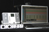 The Ultimate Portable Studio by Gina Fant-Saez — If you’re a musician, producer, engineer, or songwriter who wants to set up a professional, laptop-based recording studio, here’s all the information you need. Wow, this makes my podzilla recorder look really dinky.
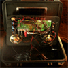
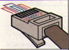 Great resource of pinouts. This is a collection of pinouts that I’ve gathered over the years and umpteen hours of buzzing out cables. Since others are bound to find some of this information useful, I’ve cleaned it up and html-ized it, but hopefully in a non-obtrusive way so that it is still useable from an 80-column dumb terminal.