
DIY GPS LCD Display
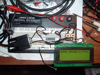 The whole idea is, I have several GPS units with no display and I wanted an easy way to see my position. I have the option with the HamHUD II to see this, but it uses up precious display space that I rather use to display some APRS related information instead. So, I need a way to take the NMEA data comming out and display it in a simple format that can be read easily while driving down the road. Link.

 PSPKrazy has released PSP FTPD v0.01, a simple, but working FTP server for your PSP. With it, you can send files to your PSP without any cables, in Wireless (WIFI). It is based on psppet ‘s networking example and some parts were taken from theno23’s httpd. It is a complete rewrite of a ftp daemon for education purposes.
 It’s summer time, so you might want to geek out your grilling…Instead of tending the fire yourself, a small control system can tend it for you, controlling the air flow to maintain a set temperature. You could enhance our design to warn you to add fuel during a very long smoke cycle.

 This is really interesting- Box.net’s filefeed lets people easily subscribe to your shared files through any web or software-based RSS reader (including firefox, my.yahoo, newsgater, feedster, and more). Distributing files through filefeed is easy: just add a file to one of your Box.net shared folders and all of the subscribers will instantly receive a link to that new file. Imagine the possibilities… share documents with your blog’s readers, send brochures to clients, syndicate recent photos automatically to friends and family, or simply use RSS to sync up your web folder with another location.
 Ever wanted to save that video or flash animation that you found on the web to your hard drive? Well, if you’re using Mozilla Firefox, it’s actually pretty easy. This tutorial will not work with anything streamed or encapsulated (e.g., streaming videos and quicktime trailers like on trailers.apple.com). Capturing those is beyond the scope of this howto [
 Another great google map hack, handy for when you want to see the streets over a sat image. Click and drag anywhere, just like normal Google Maps, and see how the Map View matches the Satellite View (or vice-versa). Control the level of transparency with the slider control at bottom